
With 3,200 miles of shoreline and one of the nation's most active waterways, Michigan claims more lighthouses than any other state in the nation. Each of Michigan's lighthouses plays an important part in keeping the Great Lakes safe.
Michigan's lighthouses range from short and utilitarian to tall and elegant. Some lie silently forgotten while others have been beautifully restored. The dozens of lighthouses are certainly worth a visit and many are open for tours, usually seasonally. Some now serve as museums or bed and breakfasts while others are privately owned but can still be admired and photographed from afar.
Lighthouses have been around since ancient Egypt, and in years past lighthouses have represented the final stretch of a journey to weary sailors, or the most hazardous portion of a long voyage. Today they stand as modern-day monuments to the history of a maritime community.
Before GPS and other navigational aids, lighthouses served two primary purposes. The first was to illuminate waterways made treacherous by shoals, reefs, rocks and other hazards. Most lighthouses also included fog signals to warn ships of hazards during periods of low visibility.
Lighthouses also served as a reference. Individual lighthouses were distinguished by color schemes and patterns on the tower, along with its light signature. For example, one lighthouse might emit two flashes every three seconds to distinguish it from a lighthouse that emits four flashes every three seconds. Even today, if the GPS malfunctions, crews reference light lists to plot their course.
No two lighthouses have been built the same and early lighthouses were built with whatever materials were available locally, including wood, brick, stone, concrete, reinforced steel and cast iron. Some lighthouses reside onshore overlooking the water while others are built offshore on reefs or rocks. The height of the tower will also change from one lighthouse to the next depending on the view from the water. A lighthouse overlooking a 100-foot cliff doesn't' need to be as tall as one closer to sea level.
Below is a list along with descriptions, GPS coordinates, interactive maps that can provide directions, and our photographs of what we feel are the most noteworthy lights.
All photos copyright John Hultgren.

Upper Peninsula From North to South
1 GPS: N 46°59.5710', W 089°07.5438'
Fourteen Mile Point Lighthouse
Lincoln Avenue, Ontonagon, MI.
The station was built in 1894 on Lake Superior and deactivated in 1934.
Fourteen Mile Point Light Station is located on private property some 14 miles east of Ontonagon. The old trail the keepers used has long since overgrown and has become impenetrable. While views of the station can be had from a boat, anyone attempting to photograph the station are requested to honor the privacy rights of the owners, and do so from offshore. Special arrangement can be made through the Historical Society at (906) 884-6165.
2 GPS: N 46°52.4040', W 089°19.5600'
Ontonagon Lighthouse
422 River Street, Ontonagon, MI.
The station was built in 1852 on Lake Superior and deactivated in 1964.
The Ontonagon Lighthouse, owned by the Ontonagon County Historical Society, is open for guided tours Monday-Saturday throughout the tourism season, and on Sundays or during the off-season by appointment. Because the lighthouse is surrounded by private property, the Historical Society offers tours with a bus and a guide. The lighthouse can be viewed and photographed from across the Ontonagon River (and is especially beautiful at night shining through the night sky) from a public beach along Lake Superior, directly east of this lightthouse and the Ontonagon River, with access from Lakeshore Park.
3 GPS: N 46°52.7682', W 089°19.8504'
Ontonagon West Pierhead Light
Ontonagon, MI.
The station was built in 1900 on Lake Superior with an 32-foot focal height.
The light can be viewed and photographed from a public beach along Lake Superior with access from Lakeshore Park.
4 GPS: N 47°14.0760', W 088°37.8240'
Keweenaw Waterway Upper Entrance Light
McLain State Park in Hancock Township, MI.
The station was built in 1874 on Lake Superior with an 82-foot focal height and automated in 1973.
Located in McClain State Park which offers two miles of sand beach on Lake Superior.
5 GPS: N 47°23.5104', W 088°22.2348'
Sand Hills Lighthouse Inn
6029 Five Mile Point Road, Ahmeek, MI.
The station was built in 1919 on Lake Superior with a 93-foot focal height and automated in 1939. It was deactivated in 1954.
Located on the Keweenaw Peninsula of the Upper Peninsula, this Victorian Inn has eight rooms, all with private baths. The Inn is a totally smoke free, adult environment with no pets and has 3000 ft of private Lake Superior shoreline. They offer one daily lighthouse tour.
6 GPS: N 47°24.8142', W 088°17.9082'
Eagle River Lighthouse
Eagle River, MI.
Built in 1855 along Lake Superior at the south end of the Eagle River, it was deactivated in 1908 and is now a private residence.
7 GPS: N 47°27.5784', W 088°09.5580'
Eagle Harbor Lighthouse
M 26 Lighthouse Drive, Eagle Harbor, MI.
The station was built in 1851 on Lake Superior with a 60-foot focal height and automated in 1980.
This light is located 32 miles northeast of Houghton and was built in 1851 as an octagonal brick tower with an attached dwelling. A fog signal building was added in 1895. It is still an active light and the keeper's dwelling is operated as a public museum. The Keweenaw County Historical Society operates a nautical and historical museum in the lighthouse and surrounding buildings. A Heritage Site of the Keweenaw National Historical Park.
8 GPS: N 47°28.4544', W 087°51.6054'
Copper Harbor Lights
15223 U.S. Highway 41, Copper Harbor, MI.
The station was built in 1849 on Lake Superior with a 90-foot focal height and automated in 1919.
The lighthouse is located within Fort Wilkins Historic State Park. Built in 1844, Fort Wilkins was intended to keep law and order during the Copper Rush and the fort tells the story of life on the northern frontier during the mid-1800s. The park also includes the two Copper Harbor lighthouses built in 1866 and 1868. Historical interpretation, including the Living History program, is provided by the Michigan History Center. Open daily, 8:30 a.m. to dusk, from May 17 through October 17, 2021.
Located in the northern Keweenaw Peninsula, Fort Wilkins Historic State Park offers camping, day-use facilities, a restored 1844 military outpost and one of the first lighthouses on Lake Superior. A Michigan Recreation Passport is required for all Michigan state parks, trails, historic sites, boat launches, harbors, and more. One mile east of Copper Harbor on US-41.
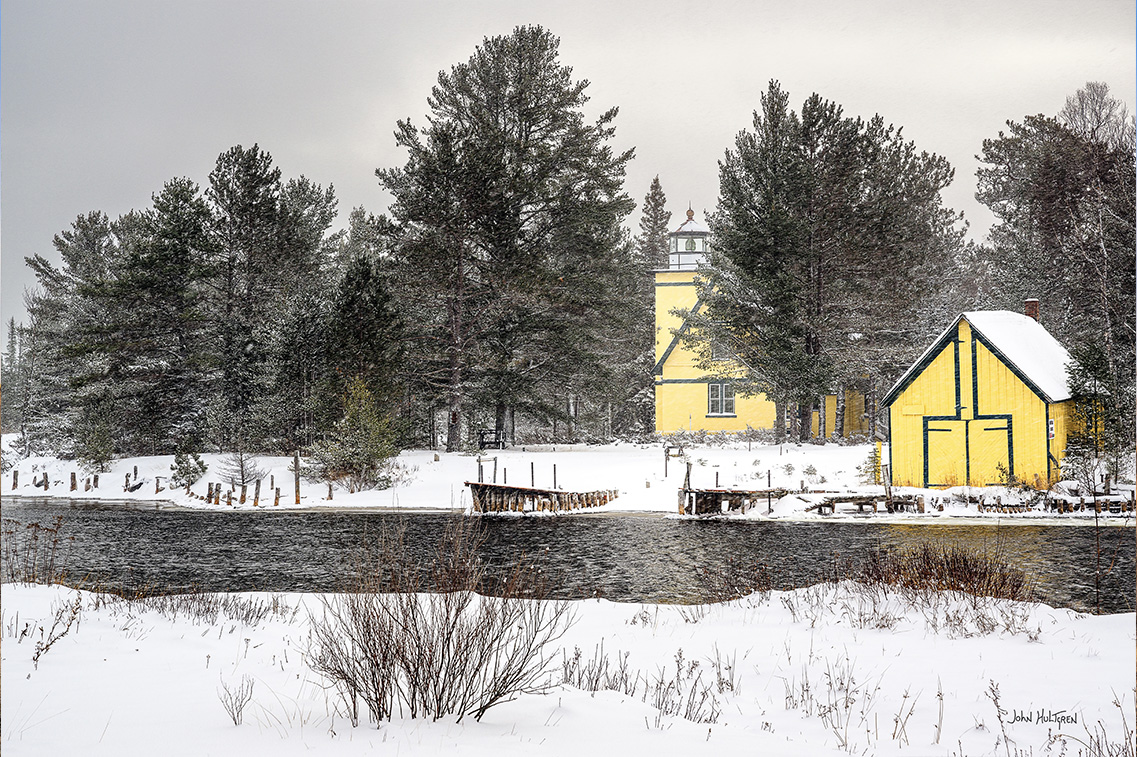
9 GPS: N 47°25.0332', W 087°39.8166'
Gull Rock Light
Manitou Island, offshore west.
The station was built in 1867 on Lake Superior with a 50-foot focal height and automated in 1913.
The Gull Rock Light Station is an active lighthouse located on Gull Rock, just west of Manitou Island and three miles east of the tip of Michigan's Keweenaw Peninsula in Lake Superior. The island is so small that during stormy weather waves wash over the entire area, leaving only the house and its square brick tower to withstand the forces of nature.
10 GPS: N 47°25.1820', W 087°35.2212'
Manitou Island Light Station
Manitou Island, MI.
The station was built in 1850 on Lake Superior with an 81-foot focal height and automated in 1978.
The Manitou Island Light Station is located off the eastern tip of the Keweenaw Peninsula in Lake Superior. The skeletal tower and keeper's dwelling are among the oldest on the Great Lakes. A modern fog signal building was built in 1930. The lighthouse is closed to the public but the grounds are open for visitation. A dock lies roughly ⅔ of a mile from the lighthouse to the west along a rough trail through the forest. Do not attempt the crossing from the mainland unless you are a competent boater.
11 GPS: N 47°22.4388', W 087°58.0122'
Bete Grise (Mendota) Lighthouse
PO Box 225, Bete Gris, MI.
The station was built in 1870 on Lake Superior with a 44-foot focal height and automated in 1933.
This lighthouse was deactivated between 1960 and 1998 but is now active. It is privately owned.
12 GPS: N 46°58.1280', W 088°25.8702'
Portage River Entry (Keweenaw Waterway Lower Entrance Light)
PO Box 76, Chassell, MI.
The station was built in 1868 on Lake Superior with a 68-foot focal height and automated in 1973.
Accessible from White City Park near Jacobsville, this light sits at the end of a half-mile concrete breakwater. The steel octagonal lighthouse stands upon a square concrete base, rising 68' above the lake level to the active beacon at the top. Diamond-shaped windows in the lantern room and the iron parapet create a distinctive appearance unlike any other in the Great Lakes. The Keweenaw Waterway Lighthouse Conservancy acquired the Lower Entrance Light from the U.S. Coast Guard in September 2016 and is slowly working to preserve this unique historical resource for the community to enjoy. The breakwater and adjacent beach are open to the public, and once safety enhancements are complete the lighthouse will be open for scheduled tours. The road out to the lighthouse is not plowed in winter for the last half-mile or so.
13 GPS: N 46°57.7860', W 087°59.9274'
Huron Island Lighthouse
Located at Mouth of Huron Bay, L'Anse, MI.
The station was built in 1868 on Lake Superior with a 197-foot focal height and automated in 1972.
The lighthouse stands atop Huron Island, the second largest island of the Huron Islands chain in southern Lake Superior. The lighthouse was built to guide vessel traffic between Marquette and Pequaming, and between the L'Anse/Baraga and Houghton/Hancock ports via the Portage entry in the state of Michigan. The lighthouse is approximately three miles north of Huron Point and the Huron Mountains, some twenty miles east of the Keweenaw Peninsula. No public access to the islands is available at this time.
14 GPS: N 46°50.4840', W 087°40.8180'
Big Bay Point Lighthouse Bed & Breakfast
4674 County Road KCB, Big Bay, MI.
The station was built in 1896 on Lake Superior with an 89-foot focal height and automated in 1941. It was deactived from 1961 through 1990 and is now privately owned and active.
Big Bay Point is one of the few surviving resident lighthouses in the country nestled on the cliffs of Lake Superior. The road to the lighthouse is posted as a private road with no trespassing.
15 GPS: N 46°43.2420', W 087°24.7248'
Granite Island Lighthouse
Marquette, MI.
The station was built in 1868 on Lake Superior with an 96-foot focal height and automated in 1939.
Located in Marquette county on the northwest tip of Granite Island in Lake Superior.
16 GPS: N 46°32.7960', W 087°22.5906'
Marquette Harbor Lighthouse and Maritime Museum
300 North Lakeshore Blvd, PO Box 1096, Marquette, MI.
The station was built in 1853 on Lake Superior with a 77-foot focal height.
The Marquette Maritime Museum offers guided lighthouse tours of the Marquette Harbor Lighthouse and this is the only way to view this picturesque light. Tours run daily mid-May through mid-October, 11:30 a.m., 1:00 p.m., and 2:30 p.m. Group tours can also be arranged by calling the Museum. The tour consists of a walk through the Coast Guard grounds where visitors will get a brief history of the Life Saving Station and Coast Guard in Marquette before reaching Lighthouse Point. Once there, visitors are treated to the history of the lighthouse and get to explore the grounds and the living quarters. The tour ends with a walk down the front catwalk. This is the only place to get a photograph of the front of the lighthouse and also see Marquette's historic shoreline.
17
Front Range Light GPS: N 46°24.9006', W 086°39.6762'
Rear Range Light GPS: N 46°24.7488', W 086°39.8394'
Munising Range Lighthouses
M 28 and Hemlock Street, Munising, MI.
Both were built in 1853 on Lake Superior. The Front Range Light has a 79-foot focal height and the Rear Range Light has a 107-foot focal height.
This site consist of a pair of 1908 lighthouses that are still in use today. The front range light is a tower that is blinded to provide the range beam. The tower is a white-steelplated conical tower and stands about 50 feet tall. The rear range light is located farther inland and stands upon a small hill. This tower is 30 feet tall. By lining up the two lamps, mariners may navigate within the channel.
18 GPS: N 46°33.5760', W 086°40.7940'
Grand Island North Lighthouse
Grand Island, Munising, MI.
The station was built in 1854 on Lake Superior and automated in 1927. It was deactivated in 1961 and inactive, with a private owner.
On the northwest point of Grand Island. Since the Grand Island North Lighthouse is on private property, it cannot be viewed from land. Also, its location atop the cliff precludes viewing from the water, leaving views from the air the only possibility.
19 GPS: N 46°27.3972', W 086°37.3866'
Grand Island East Channel Lighthouse
Grand Island, Munising, MI.
The station was built in 1870 on Lake Superior and deactivated in 1913. It is currently inactive.
This lighthouse sits on the southeast shore of Grand Island on private property. The lighthouses function was replaced by the Munising Range Lights.
20
Outer Light GPS: N 46°41.0226', W 085°58.3158'
Inner Light GPS: N 46°40.5984', W 085°58.2792'
Grand Marais Harbor of Refuge Lighthouses
Grand Marais, MI.
The station was built in 1895 on Lake Superior.
The Grand Marais Harbor of Refuge Inner and Outer Lights are a pair of lighthouses located on the west pier at the entry to Grand Marais Harbor of Refuge. In the 1870s, shipping traffic through Lake Superior increased tremendously. Realizing the lack of a safe harbor between Whitefish Bay and Grand Island, the Army Corps of Engineers began upgrading the harbor at Grand Marais in 1881. The lightkeeper's house is operated as a museum.
21 GPS: N 46°40.3650', W 086°08.3598'
Au Sable Point Lighthouse
Highway 28 to Highway 77, Grand Marais, MI
The station was built in 1874 on Lake Superior with a 100-foot focal height. It was automated in 1958 and is active.
The Au Sable Point Lighthouse is listed on the national register of historic places and was built in 1874 to warn mariners of a dangerous reef off of the Au Sable Point. Now automated, the light station is being restored to its 1910 appearance. Guided tours are offered July and August and the grounds are always open, although access is limited by snow from November through April.
22 GPS: N 46°45.1758', W 085°15.4392'
Crisp Point Light Historical Society & Lighthouse
1944 CR-412, Newberry, MI
The station was built in 1904 on Lake Superior with a 62-foot focal height. It was deactivated in 1947.
The lighthouse is located approximately 15 miles west of Whitefish Point in a remote area in Michigan's Upper Peninsula. It was constructed in 1903 and 1904 and became operational on May 5, 1904. It was decommissioned in 1993. The lighthouse was once crowned with a fixed 360 degree, red, fourth order light and stands 58 feet from its base to the ventilator ball of the lantern. Originally this site contained a lifesaving station and quarters, a two family brick light keeper's house with basement, a brick fog signal building, an oil house, two frame barns, a boat house and landing, a tramway, a lighthouse tower, and a brick service room entrance building. Today the lighthouse stands with its newly built (2006) service building and a newly built (2009) nearby visitor's center that replicates the fog horn building. Most of the service room was washed away by Lake Superior in November of 1996. In January of 1998, the Crisp Point Lighthouse Historical Society had stone placed in front of the lighthouse tower to protect it from Lake Superior.
NOTE: Do not rely on GPS directions until you get to the corner of M-123 & CR-500, located at GPS N 46°33.8400', W 085°20.6700', or you may end up on some roads only fit for 4x4's or less. Erosion from Lake Superior is a constant concern.
23 GPS: N 46°46.2382', W 084°57.4497
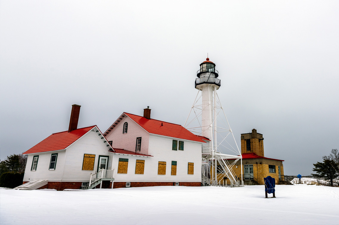
Whitefish Point Lighthouse
Paradise, MI.
The station was built in 1848 on Lake Superior with an 80-foot focal height and automated in 1970.
Located on the southeastern shores of Lake Superior, this lighthouse sits at the edge of Whitefish Point leading to Whitefish Bay and is the oldest operating lighthouse in the Upper Peninsula. All vessels entering or exiting Lake Superior pass near Whitefish Point. The area is infamously known as the "Graveyard of the Great Lakes" due to the high number of shipwrecks in the area, most famously the SS Edmund Fitzgerald.
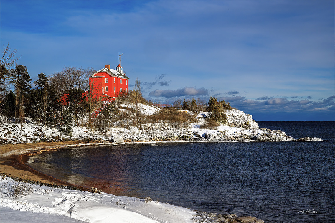
24 GPS: N 45°56.9058', W 083°54.2358'
DeTour Reef Lighthouse
Lighthouse Rd, DeTour Village, MI.
The station was built in 1847 on Lake Huron with an 74-foot focal height and automated in 1974.
Tours and Weekend Keeper programs are available from mid-June through August. The DeTour Reef Light Preservation Society volunteers have worked since 1998 to restore and preserve the DeTour Reef Light, located one mile offshore in northern Lake Huron at the far eastern end of Michigan’s Upper Peninsula between DeTour Village and Drummond Island. Built in 1931, the 83-foot tall lighthouse is a strategic and historic landmark that marks a dangerous reef to help guide ship traffic from and to Lake Huron and Lake Superior via the strategic St. Mary’s River. The DRLPS completed major restoration of the structure in 2004, and a weekend program and public tours to this unique lighthouse began in July 2005. The DRLPS received the 2005 Governor's Award for excellence in historic preservation, and the Superior Award in 2006 from the Historical Society of Michigan and the DeTour Reef Light is listed on the National Register of Historic Places. In 2010 the DRLPS was the first volunteer group in Michigan to be designated a Preserve America Steward by First Lady Michelle Obama.
25 GPS: N 45°54.7854', W 084°08.9190'
Martin Reef Lighthouse
Cedarville, MI.
The station was built in 1927 on Lake Huron with an 65-foot focal height and is automated.
Located at the north end of Lake Huron, between the St. Mary's River and the Straits of Mackinaw, about 7 miles south of the Les Cheneaux Islands to warn boaters of shallow water. The Martin Reef light can only be viewed by private boat or airplane.
26 GPS: N 45°51.9564', W 084°42.9276
Wawatam (Saint Ignace) Lighthouse
Saint Ignace, MI.
The station was built in 1998 as an architectural folly at the Monroe Welcome Center on Interstate 75 near Monroe, Michigan in the southeastern corner of the state near the Ohio border. It was a functional lighthouse structure that was constructed far away from navigational waters as an element of the tourist heritage of the state. The new Lighthouse is duly noted on newer navigational charts.
This classic lighthouse started life in 1998 as a Michigan Welcome Center travel icon at Monroe, Michigan. In 2004, the Monroe Welcome Center was being revamped and the lighthouse was put up for relocation. The City of St. Ignace was the lucky recipient and the structure was trucked north in five pieces. It stayed on the Chief Wawatam Dock for a time, awaiting the construction of its new platform. The red, white and green lighthouse was repainted in bright white with red accents. In June 2006, a crane reassembled the tower on its new site. Everything was in readiness, just waiting for U.S. Coast Guard certification. Wawatam Lighthouse takes its name from the late railroad ferry Chief Wawatam, which used this same dock from 1911 through the mid-1980s. When you visit the lighthouse, you will pass right by the Chief''s old lift gate. Wawatam Lighthouse's beacon was first lit on August 20, 2006. Visible for more than 13 miles out over Lake Huron, it is now an official aid-to-navigation. The 250 millimeter Fresnel lens casts its light in a 152 degree arc. The tower is 52 feet tall, but the Coast Guard rates it as 62 feet tall from the water. It is even lit in the winter to guide snowmobiles across the frozen lake.
27 GPS: N 45°50.2380',W 084°37.0140'
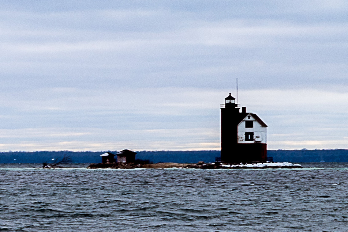
Round Island Light
Mackinac Island, MI.
The station was built in 1895 on the Straits of Mackinac with a 53-foot focal height and automated in 1924.
Also known as the "Old Round Island Point Lighthouse," this lighthouse is located on the west shore of Round Island about 0.6 miles from the shoreline of Mackinac Island in the shipping lanes of the Straits of Mackinac, which connect Lake Michigan and Lake Huron. This island is a significant hazard to navigation in the straits, and a lighthouse was seen as an effective complement to the other lights in the area. Because of its color scheme and form — red stone base and wood tower — it has been likened to an old-fashioned schoolhouse. Ferries regularly pass it on their way to (and from) Mackinac Island, and it is a recognizable icon of the upper Great Lakes.
28 GPS: N 45°51.3054', W 084°51.8178'
St. Helena Island Lighthouse
St. Helena Island, Saint Ignace, MI.
The station was built in 1873 in the Straits of Mackinac with a 71-foot focal height and automated in 1922.
In 1986 the Great Lakes Lighthouse Keepers Association along with local Boy Scout troops started preservation. This lighthouse is a constant reminder of the many small vessels that took refuge in the natural harbor on the north side of St. Helena Island.
29 GPS: N 45°55.2792', W 085°54.7398'
Seul Choix Pointe Lighthouse
905 S Seul Choix Pointe Road, Gulliver, MI.
The station was built in 1892 in Lake Michigan with an 80-foot focal height and automated in 1972.
The Seul Choix Pointe Lighthouse Park and Museums are owned by the State of Michigan, but operated by a non profit organization, The Gulliver Historical Society, Inc. An operational Light, it is the only working light on the Northern shores of Lake Michigan. Includes a fully restored house, Tower Tours, Fog Signal Area History Museum, a Boat House Museum, mini Oil House Museum, Gift Shop, 30 seat Theater, Assistant Keepers House and Research/Genealogy Library. Open Memorial Day thru the end of Sept, 10:00am-6:00pm. Last Tower Tour is 5:30pm.
30 GPS: N 45°54.2238', W 085°33.7032'
Lansing Shoal Lighthouse
Gulliver, MI.
The station was built in 1900 in Lake Michigan with a 69-foot focal height and automated in 1976.
Located about six miles off of the coast, the lighthouse is about 9 miles north of Beaver Island and was built in 1928. In 1985 it was converted to solar power and its third order fresnel lens was removed and put on display in the Michigan Historical Museum in Lansing.
31 GPS: N 45°56.6886', W 086°14.8554'
Manistique East Breakwater Lighthouse
Manistique, MI.
The station was built in 1915 in Lake Michigan with a 50-foot focal height and automated in 1969.
Located in Schoolcraft county on the end of the east breakwater.
32 GPS: N 45°40.0836', W 086°58.0182'
Peninsula Point Lighthouse
Country Road 513, 19 miles south of Rapid River, Rapid River, MI.
The station was built in 1856 in Lake Michigan with a 40-foot focal height and automated in 1922.
Built in 1864 to aid sailing ships in avoiding dangerous shoals hidden off the channels. The 1-½ story brick home was destroyed in 1959 by fire but the 40-foot light tower is open. A hiking trail through the wooded shoreline offers wildlife viewing with ducks, geese, gulls and shorebirds. During the migration seasons look for monarch butterflies, spring warblers and blue herons. Restrooms and picnic areas are available.
33 GPS: N 45°44.6808', W 087°02.6598'
Sand Point Lighthouse
16 Water Plant Road, Escanaba, MI.
The station was built in 1867 on Lake Michigan with a 44-foot focal height. It was decommissioned in 1934.
Established in 1867 by the National Lighthouse Service, Sand Point's light has guided ships through squalls and shoals throughout its colorful history. A fire in 1886 destroyed the structure, but the lighthouse was rebuilt and served the sailing public until its decommissioning by the Coast Guard in 1939. Today an electronic club light guides boats into the harbor, and the lighthouse has been restored as a maritime museum.
34 GPS: N 45°05.8380', W 087°35.1600'
Menominee North Pier Lighthouse
Harbor Drive, Menominee, MI.
The station was built in 1887 on Lake Michigan with a 46-foot focal height. It was automated in 1972.
The first light was built in Menominee in 1877 to guide ships to the Menominee River. The current tower was built in 1927. The 34-foot tower was painted white and integrated with an attached fog signal building. The light was automated in 1972 and at that time the iron catwalk was removed from the pier. The tower was then painted red and relocated to a concrete platform in the center of the crib. The octagonal cast iron lantern room once housed a fourth order Fresnel lens. Today, a 300mm optic lens operates.
Lower Peninsula From East to West
35 GPS: N 42°00.0492', W 083°08.4750'
Detroit River Light
Lake Erie south of Detroit River, Detroit, MI.
The station was built in 1875 on Lake Erie with a 55-foot focal height. It was automated in 1979.
This light is located two miles offshore in Lake Erie toward the Detroit River. The light can only be viewed by water or air and is not open to the public.
36 GPS: N 42°10.0920', W 083°08.3940'
Grosse Ile North Channel Front Range LighthouseThe station was built in 1894 on the Detroit River. It was deactivated in 1963. The rear light was destroyed and the front light is inactive. It is privately owned.
The structure is in good condition considering it was built in 1906. It stands 40 feet tall. The eight sided lantern room is empty now. The Grosse Isle Historical Society will give tours of this light but, since it is on private land, visitors must be escorted to the light by members of the society.
37 GPS: N 42°20.8218', W 082°57.2580'
William Livingstone Memorial LightThe station was built in 1930 on the Detroit River with a 58-foot focal height.
Located on the northeast end of Belle Isle in the Detroit River, this light is unique in two ways. It is the only light in the nation constructed of marble and it is one of only two lights in Michigan erected as memorials.
38 GPS: N 42°42.9816', W 082°29.4924'
Peche Island Lighthouse TowerThe station was originally built in 1908 on Lake St. Clair with a 114-foot focal height. That location was replaced with skeleton tower and the original tower was moved to its current location at Marine City Waterfront Park.
This lighthouse was originally built in 1908 off Peche Island, Ontario, at the head of the Detroit River.
39
Front Light: GPS: N 42°32.2740', W 082°41.5920'
Rear Light: GPS: N 42°32.3700', W 082°41.3940'
The station was originally built in 1859 on Lake St. Clair. Only the front light is active.
Located in Lake St. Clair 0.7 miles west of the southern tip of Harsens Island, about ¾-mile from shore. This is not open to the public.
St. Clair Flats Front and Rear Range Light are two lighthouse structures situated off the southeastern tip of Harsens Island at Lake St. Clair. Constructed in 1855–1859, the Old South Channel Range Lights were built to guide ships into the fresh water delta once known as the Venice of America. The front light began to lean in 1875 and was dismantled and rebuilt on the same stone and timber crib that it had been built on originally. It remained but is again leaning and in very bad condition from erosion of the base. In 1990, a steel cell was placed around the base, reinforced and filled with limestone for temporary support until a permanent seawall could be built. In the fall of 1996, a permanent seawall was completed around the front light island. The rear light was built on the same type of crib but has weathered the elements over the years. There was a large keeper's house on the island surrounding the light that was taken down in the early 1930s. Vandalism has played a part in the overall deterioration and, combined with age and the elements, the rear light is also in need of major foundation work.
40 GPS: N 43°00.3786', W 082°25.3452
Fort Gratiot LightThe station was originally built in 1825 on Lake Huron with an 82-foot focal height. It was automated in 1933.
The oldest operating lighthouse in the Great Lakes and rebuilt in 1829 and 1861, this was the first lighthouse on Lake Huron and it is the oldest surviving lighthouse in Michigan. The 86 ft. light stands above the lake level in a conical stone tower, overlaid with red brick that has been painted white. The keeper's cottage and fog whistle house are red. Tower climbs and tours are available during business hours, weather permitting, and closed-toe shoes are required.
41 GPS: N 43°25.7406, W 082°32.4120'
Port Sanilac Light
Lake Street, Port Sanilac, MI.
The station was originally built in 1886 on Lake Huron with a 69-foot focal height. It was automated in 1925.
This lighthouse originally burned kerosene but was electrified in 1929. It is now a private residence but the light remains an active aid for navigation.
42 GPS: N 43°50.7396', W 082°37.8780'
Harbor Beach Light
View from Waterworks Park & Harbor Beach, Harbor Beach, MI.
The station was originally built in 1858 on Lake Huron with a 54-foot focal height. It was automated in 1968 and is owned by the City of Harbor Beach.
Located at the end of the north breakwater entrance to the harbor of refuge, created by the U.S. Army Corps of Engineers, protecting the harbor of Harbor Beach. Located on the Thumb on Lake Huron, the Harbor Beach lighthouse has been guiding mariners along the shore and into the former "world's greatest man made harbor" for over 125 years. The lighthouse has been completely restored and offers tours every Saturday during the summer. Tour reservations are recommended but not always available.
43 GPS: N 44°01.3716', W 082°47.5938'
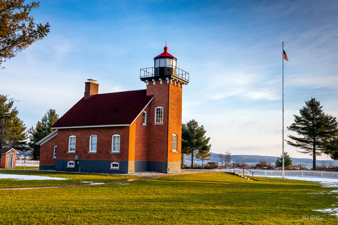
Pointe aux Barques Lighthouse and Museum
7320 Lighthouse Road, Port Hope, MI.
The station was originally built in 1848 on Lake Huron with a 93-foot focal height. It was automated in 1958.
The original Pointe aux Barques Lighthouse was constructed of stone taken from the shore of Lake Huron in 1848. The keeper's house and separate tower were located on a three acre clearing hacked out of the dense wilderness. By 1857, the ravages of shoreline weather and a fire in the interior of the house created the need for a new structure. The new keeper's house and attached 89-foot tower were built of the finest brick available. The light is still an active aid to navigation, making Pointe aux Barques one of the oldest continuously operating Lights on the Great Lakes. In 1875, a Class A lifesaving station was constructed 300 yards south of the lighthouse. It was the first lifesaving station opened on the Great Lakes. The 62 year history of the station credits over 200 rescues to this station and its brave crews. The Thumb Bottomland Preserve surrounding Pointe aux Barques contains 105 known wrecks, reflecting the danger posed by shoals surrounding Pointe aux Barques. The Pointe aux Barques keeper's house and tower have been completely restored and contain historical artifacts. The Museum is open to the public free of charge along with a gift shop. The tower is available to climb on holiday weekends at a cost for 12 years and under at $2.00 and 12 years and older at $4.00.
44 GPS: N 44°04.9212', W 082°58.9446'
Port Austin Reef Light
Two Miles Offshore, Port Austin, MI.
The station was originally built in 1878 on Lake Huron with a 76-foot focal height. It is automated.
The lighthouse is located in Lake Huron approximately 2½ miles north of the Port Austin Harbor. The station was established and first lit in 1878 and, after a devastating fire, modified in 1899. It is still operational and acts as an automated beacon. It is currently owned by the United States Coast Guard and leased to the Port Austin Reef Light Association.
45 GPS: N 43°38.1300', W 083°51.0282'
Saginaw River Rear Range Light
Saginaw River, Bay City, MI.
The station was originally built in 1876 on Lake Huron with a 77-foot focal height. It was automated in 1954 and deactivated in 1962. It is inactive and privately owned.
The range light system, which is used by all mariners and maintained nationwide by the U.S. Coast Guard, was invented in 1860 by the 15-year-old son of the keeper of Bay County's Saginaw River Lighthouse. The lighthouse is now located on private property and undergoing extensive renovation and is not accessible, but may be viewed from the water.
46 GPS: N 44°15.2322', W 083°26.9730'
Tawas Point Light
686 Tawas Beach Road, East Tawas, MI.
The station was originally built in 1853 on Lake Huron with a 70-foot focal height. It was deactivated in 2016.
Tawas Point is a destination for birdwatchers and it also offers spectacular views of sunrises over Lake Huron and sunsets over Tawas Bay. The lighthouse is open for tours seasonally and during special events in the off-season. Recreation Passport required for entry into Tawas Point State Park.
47 GPS: N 44°42.7614', W 083°16.3680'
Sturgeon Point Lighthouse
6071 E Point Road, Harrisville, MI.
The station was originally built in 1869 on Lake Huron with a 69-foot focal height. It was automated in 1939.
Located five miles north of Harrisville on Lake Huron, the light is a 3.5 order Fresnel lens made in Paris, France and it is still maintained by the U.S. Coast Guard. The keeper's house is now a maritime museum which is open to the public from Memorial Day to mid-September. The lighthouse tower is open to the public. The grounds are open all year.
48 GPS: N 45°03.6222', W 083°25.3836'
Alpena Light
250 Prentiss Street, Alpena, MI.
The station was originally built in 1877 on Lake Huron with a 44-foot focal height. It was automated in 1974.
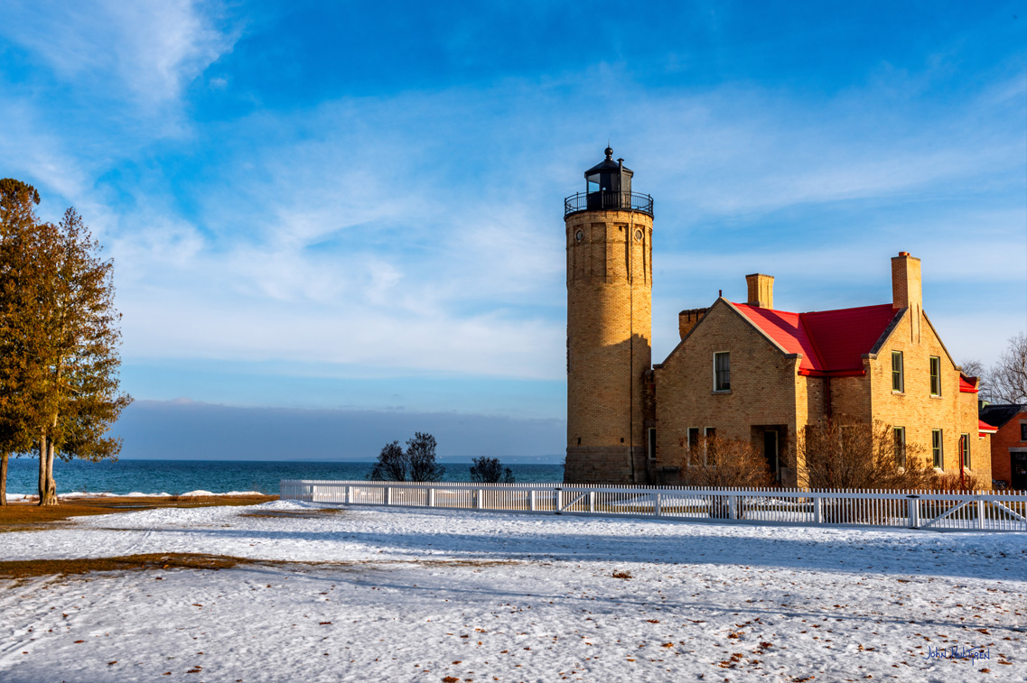
45.0604While the Alpena Light may not be a typical lighthouse, it does meet the criteria to be called one. Located at the mouth of the Thunder Bay River, the 80-foot skeletal tower is best viewed from the transient docks at the City of Alpena’s Marina near GPS N 45°03.4560', W 083°25.7460'. Called "Sputnik" because it resembles the Russian space satellite and "Little Red" by locals, it is said this oft dismissed light is "Long on duty, short on beauty." Believed to be the only lighthouse of this type in the U.S., the station was built of wood in 1877, rebuilt of wood in 1888 and finally constructed of steel in 1914. An automated active aid to navigation, the Alpena Light originally housed a Fourth Order Fresnel lens.
49 GPS: N 45°20.5230', W 083°28.6962'
Old Presque Isle Lighthouse
5295 E. Grand Lake Rd., Presque Isle, MI.
The station was originally built in 1840 on Lake Huron with a 36-foot focal height. It was deactivated in 1871.
The Old Presque Isle Lighthouse is one of the oldest surviving lighthouses on the Great Lakes. The harbor light operated until 1871 when the keeper transferred to a new, taller, coastal lighthouse a mile to the north. The Old Presque Isle Lighthouse park features two main structures, a keepers dwelling and a light tower. The stone and brick tower measures thirty feet tall and eighteen feet in diameter. Visitors can climb the hand-hewn stone steps for a panoramic view of the Lake Huron shoreline and Presque Isle Harbor. Nearby is the one-story side-gabled brick keeper’s dwelling which serves as a hands-on museum with a small gift shop. Here, visitors can blow foghorns and examine other interesting artifacts. They can also ring the bell from the Lansing City Hall clock tower. Tipping the scales at an impressive 3,425 pounds, this bronze bell is much bigger than the Liberty Bell, which weighed 2,080 pounds when cast. Visitors may also pose in an old set of punishment stocks. The buildings and park grounds are open to the public daily, from 10am until 6pm, mid-May through mid-October. A nominal fee is charged for tower climbs.
50 GPS: N 45°21.3960', W 083°29.5314'
New Presque Isle Lighthouse Park and Museum
4500 East Grand Lake Road, Presque Isle, MI.
The station was originally built in 1871 on Lake Huron with a 123-foot focal height. It was automated in 1970.
Presque Isle Light Station is a complex of three historic buildings including a lighthouse tower and two keeper's residences. Located on the Lake Huron shoreline near Presque Isle Harbor, the New Presque Isle Light is the tallest lighthouse tower accessible by the public on the Great Lakes. Built in 1870, it replaced the 1840 harbor light. The light station complex is part of a 99-acre township park that includes a playground, picnic area, pavilion and nature trails. A gift shop and museum displays are located in the original keeper's quarters connected to the tower. Admission is free. Visitors, for a nominal fee, may climb the 130 steps to the top of the tower for a spectacular view. The 1905 Keeper's House has been restored. Operated by the Presque Isle Township Museum Society, it is now a museum that provides visitors with an opportunity to learn about local maritime history, as well as how keepers and their families lived. Admission is free and donations are gratefully accepted. The buildings and grounds are open to the public daily from 10am - 6pm, mid-May through mid-October. The 1905 Keeper's House is open Memorial Day through Labor Day, 11am- 4pm, Friday through Monday.
51 GPS: N 45°29.1672', W 083°54.8202'
Forty Mile Point Lighthouse
7323 US 23N, Lighthouse Park, Rogers City, MI.
The station was originally built in 1897 on Lake Huron with a 66-foot focal height. It was automated in 1969.
Forty Mile Point Lighthouse is located on the northern shoreline of Lake Huron in Presque Isle County’s Lighthouse Park, Rogers City, Michigan. At a cost of $25,000, the station was completed by the end of 1896. Its 4th Order Fresnel lens has been a welcoming beacon to sailors since May 1897 and is still operating today. In 1996, the 40 Mile Point Lighthouse Society began restoring the lighthouse, outbuildings and grounds. Several years ago, the pilot house from the Steamer Calcite, built in 1912 and the first self-unloading steamer on the Lakes, was relocated to the reservation. The Society, with the help of many retired Great Lakes sailors, has also restored and preserved this structure. The park is open to the public year-round. The lighthouse museum, pilot house and gift shop are open 10:00am to 4:00pm Tuesday through Sunday beginning Memorial Day weekend through mid-October. Admission is free. Group tours can also be arranged.
52 GPS: N 45°41.6478', W 084°21.7092'
Poe Reef Light
Coastline, Cheboygan, MI.
The station was originally built in 1893 on Lake Huron with a 71-foot focal height. It was automated in 1974.
The lighthouse is located in Cheboygan County about 2-½ miles from the Lower Peninsula shoreline. While a private vessel is undoubtedly the best way to obtain close-up views of this Light, Sheplers Ferry Service out of Mackinaw City offers a number of lighthouse cruises during the summer season. Their "Eastbound Tour" includes passes by Round Island, Bois Blanc Island, Poe Reef and Fourteen Foot Shoal.
53 GPS: >N 45°40.7940', W 084°26.0646'
Fourteen Foot Shoal Light
Coastline, Cheboygan, MI.
The station was originally built in 1930 on Lake Huron with a 51-foot focal height. It is automated.
Located in Cheboygan county about ¾ mile from the Lower Peninsula shoreline, the lighthouse is one mile northwest of Cheboygan Point close to the main course of entry into Cheboygan Harbor.
54 GPS: N 45°46.2852', W 084°08.4024'
Spectacle Reef Lighthouse
Coastline, Cheboygan, MI.
The station was originally built in 1874 on Lake Huron with an 86-foot focal height. It was automated in 1972.
The lighthouse is eleven miles east of the Straits of Mackinac and is located at the northern end of Lake Huron, about 10-½ miles off the coast of the Lower Peninsula. It was designed and built by Colonel Orlando Metcalfe Poe and Major Godfrey Weitzel, and was the most expensive lighthouse ever built on the Great Lakes. It is said to be the most spectacular engineering achievement in lighthouse construction on Lake Huron, and ranks high amongst all of those on the Great Lakes.
55 GPS: N 45°48.6360', W 084°25.2600'
Bois Blanc Island Lighthouse
Bois Blanc Island, MI.
The station was originally built in 1867 on Lake Huron with a 32-foot focal height. It was deactivated in 1955 and is privately owned.
Located on the north end of Bois Blanc Island to mark a shoal that juts out into northern Lake Huron, the Bois Blanc Island lighthouse is a two-story, light-brick dwelling with an attached square 38-foot tower jutting out from the front. Built in 1867, it is the third lighthouse on this location.
56 GPS: N 45°47.2267', W 084°43.8087'
Old Mackinac Point Lighthouse
Mackinaw City, MI.
The station was built in 1889 on the Straits of Mackinac with a 62-foot focal height and deactivated in 1957.
Mackinaw Point marks the junction of Lake Michigan and Lake Huron. Founded in 1889, the Old Mackinac Point Light Station was in operation from 1890 until 1957.
57 GPS: N 45°47.2290', W 084°46.3824'
McGulpin Point Lighthouse
500 Headlands Drive, Mackinaw City, MI.
The station was built in 1869 on the Straits of Mackinac with a 102-foot focal height.
The lighthouse is located two miles west of downtown Mackinaw City and has been restored to period decor by Emmet County. McGulpin Point was one of Michigan's first deeded properties and was important grounds for Odawa (Ottawa) Indians, French, and British settlers in the Straits of Mackinac. It was an operational lighthouse from 1869-1906, when it became privately owned. Emmet County purchased the lighthouse and its acreage in 2008 and has worked to restore it to period decor. There is a gift shop and docents on site, and no admission charge. Open mid-May to mid-October with special events throughout the year. In 2010, McGulpin once again became an operational Aid to Navigation on the NOAA chart map.
58 GPS: N 45°25.1660', W 084°58.6948'
Little Traverse Light
Harbor Point, MI.
Built in 1884 on Lake Michigan with a 72-foot focal height.
Not accessable to the public, on land marked "No Trespassing". Photo taken with permission.
The Little Traverse Light is located in Emmet County on the north side of the Little Traverse Bay of Lake Michigan on Harbor Point near Harbor Springs, Michigan. It marks the entrance to the harbor at Harbor Springs.
59 GPS: N 45°19.1526', W 085°15.8916'
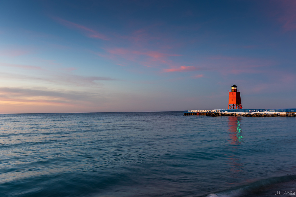
Charlevoix South Pier Light Station
Michigan Beach Park, Charlevoix (Charlevoix County) MI.
The station was built in 1914 on Lake Michigan with a 41-foot focal height.
Located at the entrance to Lake Charlevoix in Charlevoix County, at the end of the south pier/breakwater of the channel leading to Round Lake in the city of Charlevoix. In 1989 the present steel and concrete pier replaced the old wooden pier with its concrete covering. The present piers and revetments were constructed in the 1970s and 1980s. The construction is specially designed to withstand unusually forceful wave pressures, and to protect the harbor.
60 GPS: N 44°59.4786', W 085°28.7682'
Old Mission Point Lighthouse
20500 Center Road, Traverse City, MI
The station was built in 1870 on Lake Michigan with a 47-foot focal height. It was deactivated in 1933.
This light is now maintained by Peninsula Township and short-term keepers are allowed to live in the lighthouse, which is halfway between the North Pole and the Equator exactly on the 45th parallel and which was decommissioned in 1933. Hours are 10am to 5pm, daily, May - October and weekends only in November. The park, beach and trails are always open. Self-guided tours are available seven days a week which includes access to the tower. Adults - $4, Children - $2, Children five and under - free. Grounds and dwelling/tower are open in season.
61 GPS: N 45°12.6162', W 085°32.9988'
Grand Traverse Lighthouse Museum
15550 N Lighthouse Point Road, Leelanau State Park, Northport, MI.
The station was built in 1852 on Lake Michigan with a 47-foot focal height. It was automated and deactivated in 1972.
This lighthouse marks the end of the Leelanau Peninsula and has guided ships in the Manitou Passage of Lake Michigan for nearly 150 years, making it one of the oldest on the Great Lakes. This lighthouse is sponsored by the Grand Traverse Lighthouse Foundation and features a historic and educational museum resembling a lighthouse keeper's home of the 1920s and 30s with a variety of exhibits depicting a broad spectrum of maritime and local history.
62 GPS: N 45°00.4548', W 086°05.6322'
South Manitou Island Lighthouse
PO Box 277, South Manitou Island, MI.
The station was built in 1839 on Lake Michigan with a 54-foot focal height. It was automated in 1935 and deactivated from 1967 through 2009.
Located on South Manitou Island seven miles off the coast of the Lower Peninsula. The Manitou Islands forms the western side of what was known as the "Manitou Passage." By traveling through this passage, vessels were able to reduce the distance between ports on the southern shores into the Straits of Mackinac by sixty miles, as compared to the trip around the islands on the lake side.
63 GPS: N 44°48.4758', W 086°15.3126'
Manning Memorial Light
Village Park, Empire, MI.
The station was built in 1990 on Lake Michigan with a 38-foot focal height.
This tower, located 7-¼ miles off the coast of the Lower Peninsula, resembles the one at Point Betsie and was built as a memorial to Robert H. Manning, a life-long resident of Empire. Located in Village Park, just west of Empire.
64 GPS: N 44°41.4750', W 086°15.3114'
Point Betsie Lighthouse
3701 Pt. Betsie Road, Frankfort, MI.
The station was built in 1854 on Lake Michigan with a 52-foot focal height. It was automated in 1984.
The oldest standing structure in Benzie County marks the all-important entrance to southern end of the Manitou Passage, a once-vital maritime shipping channel. Although the lane is no longer used by large commercial vessels, the operating light signal remains a US Coast Guard aid to navigation to this day, and the site shines as a treasured landmark to mariners and landlubbers alike. The site has been open for tours and gift shopping, primarily on weekends from Memorial Day to Columbus Day. The public beach adjacent to the site is easily accessed. Enjoy the charming Lighthouse Keeper's Quarters for weekly rentals in season.
65 GPS: N 44°37.8516', W 086°15.1332'
Frankfort North Breakwater Light
Coastline, Frankfort, MI.
The station was built in 1873 on Lake Michigan with a 72-foot focal height. It is automated.
A popular place for Lake Michigan sunsets. Located in Benzie county on the outer end of the north breakwater, visitors can walk out to the lighthouse, fish off the pier and enjoy the sights and sounds of Lake Michigan. Follow Main Street to the public beach in Frankfort where there is public parking, a playground, benches and walkway to the pier. Always use caution on windy days if the waves are splashing over the break wall.
66
North Light GPS: N 44°15.1098', W 086°20.8164'
South Light GPS: N 44°15.0888', W 086°20.9994'
Manistee Pierhead Lighthouses
Lake Michigan Coast, Fifth Avenue Beach, Manistee, MI.
The station was built in 1875 on Lake Michigan with a 44-foot (north) and a 29 foot (south) focal height. It was automated in 1927.
Located in Manistee county on the west end of the north pier. The light was replaced in 1873 when the new structure was augmented with a combination fog signal and light tower at the end of the wooden north pier. To make access to the light safer during stormy weather, this new light was outfitted with an elevated wooden catwalk running from the shore to the light.
67 GPS: N 44°03.4595', W 086°30.8583'
Big Sable Point Light
Michigan Beach Park, Charlevoix (Charlevoix County) MI.
Built in 1867 on Lake Michigan with a 106-foot focal height.
Big Sable Point Lighthouse located at Ludington State Park. The parking lot can fill up fast. This historic Great Lakes lighthouse has been completely restored and opened to visitors daily from May through October. The United States Coast Guard has transferred ownership to Ludington State Park.
68 GPS: N 43°57.2184', W 086°28.1628'
Ludington Light
Stearns Park Beach, Stearns Park Outer Drive, Ludington, MI.
The station was built in 1871 on Lake Michigan with a 55-foot focal height. It was automated in 1972.
The structure is made of steel plates in the shape of a four-sided pyramidal tower with four round porthole windows on each of its three decks. Each level has interesting items and pictures for visitors to explore as they make their way to the lantern rooms. At the top, guests are treated to a view of Ludington harbor.
69 GPS: N 43°39.0828', W 086°32.3760'
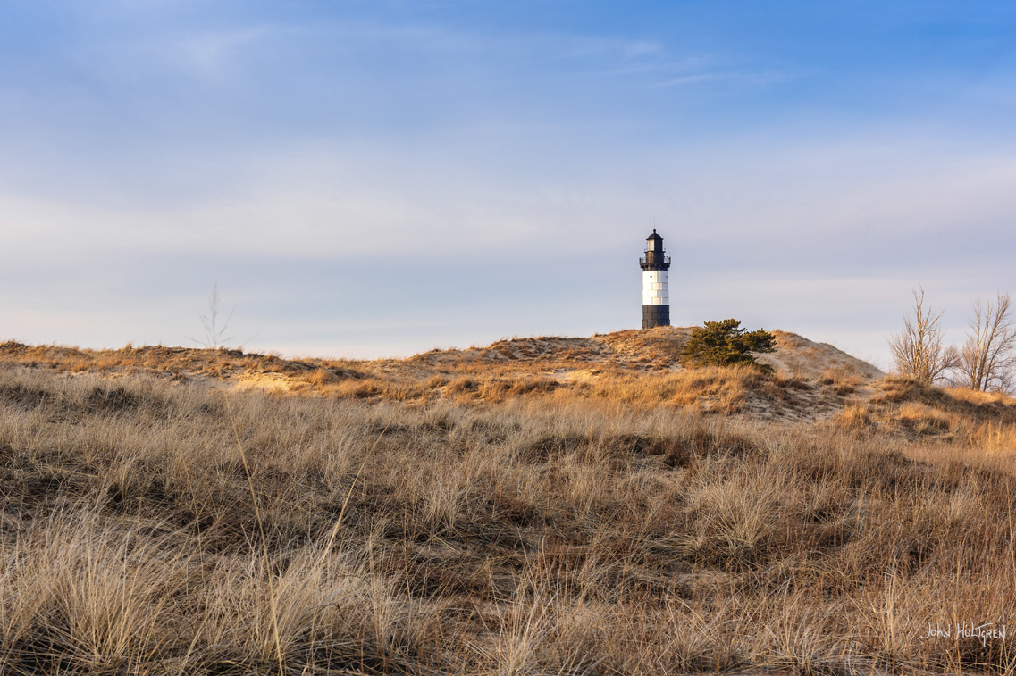
Little Sable Point Lighthouse
287 North Lighthouse Drive, Mears, MI.
The station was built in 1874 on Lake Michigan with a 108-foot focal height. It was automated in 1955.
Climb this 115-foot lighthouse to see spectacular views of the Lake Michigan shoreline and the Silver Lake dunes. Visit with volunteer keepers who will share the rich history of the lighthouse and enjoy the surrounding beach area. Little Sable Lighthouse is maintained by the Sable Points Lighthouse Keepers Association. Admission charged to climb the tower. Guided group tours available with advance reservations.
70 GPS: N 43°22.4880', W 086°25.4760'
White River Light Station Museum
6199 Murray Road, Whitehall, MI
The station was built in 1875 on Lake Michigan and was automated in 1945. It was deactivated in 1960.
Now used as a museum featuring photos, paintings, artifacts, and newspaper articles about the lighthouse, shipping, and lumbering. Open 6 days a week May 22nd through October 31 from 10am to 5pm, closed on Mondays. Admission $5.00 for Adults and $2.00 for children 12 and under.
71
Pier Light GPS: N 43°13.6008', W 086°20.4792'
Breakwater Light GPS: N 43°13.4460', W 086°20.8194'
Muskegon Pier Light and Breakwater Light
Beach Street, Muskegon, MI
The Muskegon Pier Light was built in 1903 on Lake Michigan with a 50-foot focal height. The Muskegon Breakwater Light was built in 1851 on Lake Michigan with a 70-foot focal height.
Located in Muskegon at the outer end of the south pier. Tours offered June-September.
72
North Pier Light GPS: N 43°03.4920', W 086°15.3528'
South Pier Light GPS: N 43°03.4260', W 086°15.3462'
Grand Haven North and South Pier Lighthouses
1001 S. Harbor Dr. , Grand Haven, MI.
The station was built in 1839 on Lake Michigan and automated in 1969. The north lighthouse has a with a 36-foot focal height and the south light has a 42-foot focal height.
The two lights on the south pier, both painted red, are connected by a lighted catwalk that also connects them to the shore and the Boardwalk. The inner light is cylindrical and the square outer light stands on a huge concrete foundation. People often enjoy a stroll along the boardwalk that boarders the Grand River channel and the pier, making the Grand Haven lighthouse one of the most photographed lighthouses in the Midwest.
73 GPS: N 42°46.3620', W 086°12.7440'
Holland Harbor (Big Red) Ligh
2215 Ottawa Beach Road, Holland State Park View, Holland, MI
The station was built in 1872 on Lake Michigan with a 52-foot focal height, and was automated in 1932.
Holland State Park is at the west end of Ottawa Beach Road on the northside of Holland. You can also view Big Red from Mt. Pisgah, where the dune stair case takes you 157 feet above sea level. The Lighthouse, a three-story square tower building, topped with a gray-shingled roof, is one of the most photographed lights in Michigan. The twin-gabled structure reflects the Dutch influence in the area. Twice a year, the Coast Guard inspects the facility and maintains the light. The light can be seen for 20 miles. The use of a fog signal had been discontinued. The original lens is on display in the Holland Museum. Over the years, "Big Red" has taken on a life of its own, popular with painters, photographers, beach-goers and boaters.
74 GPS: N 42°24.0828', W 086°17.2782'
South Haven South Pierhead Light
Water Street, South Haven, MI
The station was built in 1872 on Lake Michigan with a 37-foot focal height. It is automated.
South Haven's lighthouse is on the south pier.
75 GPS: N 42°06.9773', W 086°29.6650'
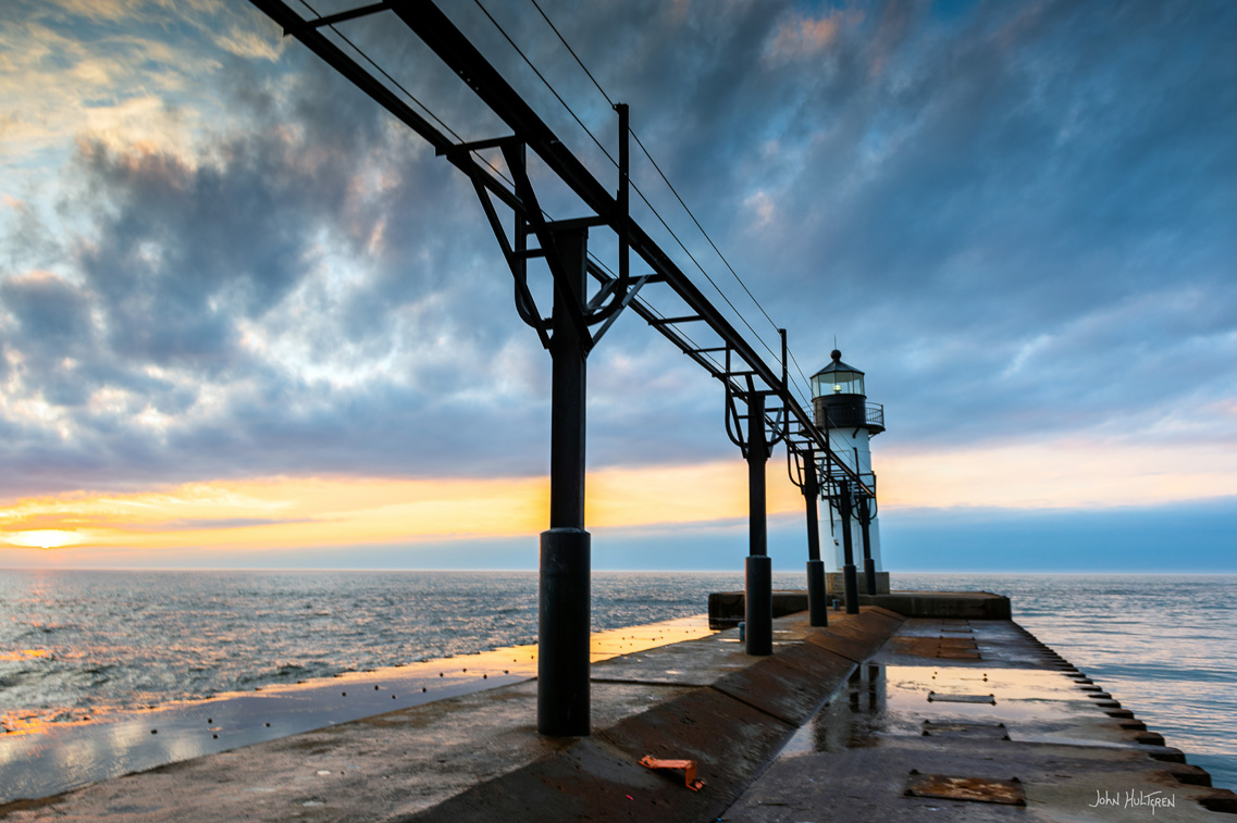
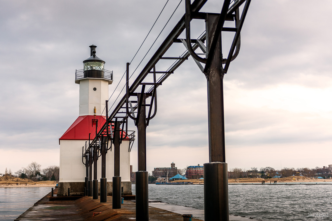
St. Joseph North Pier Inner and Outer Lights
St. Joseph, MI.
The St. Joseph North Pier Inner Light station was built in 1832 on Lake Michigan with a 53-foot focal height.
The St. Joseph North Pier Outer Light station was built in 1832 on Lake Michigan with a 31-foot focal height.
The St. Joseph North Pier Inner and Outer Lights are lighthouses at the entrance to the St. Joseph River on Lake Michigan. The current lights were built in 1906 and 1907; they were decommissioned in 2005 but still active.

 ADVERTISEMENT