
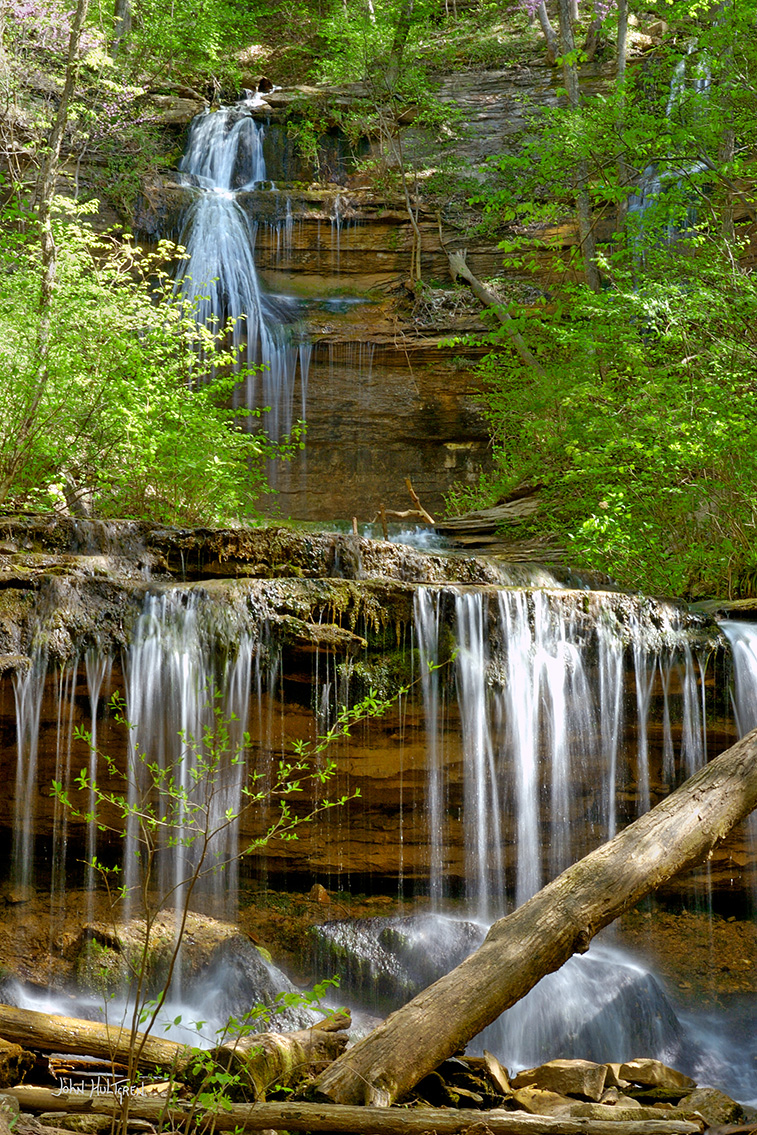
Kentucky has many magnificant waterfalls, including Cumberland Falls, Yahoo Falls, and Dog Slaughter Falls. Some are easy to access, while others are more secluded.
The most famous waterfall in Kentucky, known as the "Niagara of the South," is Cumberland Falls. It's 125 feet wide and 69 feet high and is located and easily accessible in Cumberland Falls State Resort Park. The tallest waterfall in Kentucky, at 113 feet, is Yahoo Falls, and it is located in the eastern part of the state. Eagle Falls is a 44-foot waterfall that's located in a rocky cove and is accessible via a trail in Cumberland Falls State Park. And Broke Leg Falls is a 60-foot waterfall that tumbles into a grotto-like pool that is easily accessible from the roadside via a staircase.
Kentucky is home to more than 1,140 waterfalls, and while it would be impractical to feature all of them here, you’ll find these nineteen magnificent waterfalls along forested paths, at the end of majestic mountain hikes, or even on a short trek from a parking lot. No two falls are alike, and each possesses their own legends and history that makes discovering them even more fun and memorable. For photogrqphers or hikers, each will reward you with their stunning backdrops, cool cascades, and scenic pools that will leave you awestruck with Kentucky's natural beauty.
Before heading out to explore it’s a good idea to check on current trail conditions, waterfall volume and any restrictions concerning a particular waterfall access trail. Some trails are not pet-friendly, mainly for their own protection, as well as that of the local plant and animal life. Some waterfalls are also best visited during the rainier months of the year, while others are exceptional all year-round, with wintertime offering its own magical scenic backdrop.
All photos are copyright John Hultgren.
1 Trailhead GPS: N 36°46.6998', W 085°07.5936'
Seventy Six Falls (Clinton County)
GPS: N 36°46.7496', W 085°07.5546'
A short out-and-back trail that is generally considered an easy route for walkers is great for birding and hiking. Dogs are welcome, but must be on a leash. This trail is concrete and consists of 64 steps, so it is not wheelchair accessible. Seventy Six Falls is located along Indian Creek and may have derived its name from the nearby community of Seventy Six. Despite popular belief, it wasn't named for its height, which measures around 84 feet depending on Lake Cumberland’s water levels. The trails, scenic bridges and picturesque views leading to Seventy Six Falls, as well as its sheltered picnic area near the brink of the falls, are a nice spot to spend an afternoon. The best view of Seventy Six Falls will be from the waters of Lake Cumberland. The recreation area is heavily fenced and you can see, but not access, the crest of the waterfall. You have a great view of Lake Cumberland, and a good view of the waterfall crest, but viewing the actual waterfall itself is limited.

2
Mill Spring Mill and Parking:
GPS: N 36°56.0412', W 084°46.7280'
Mill Springs Falls (Monticello)
GPS: N 36°56.0530', W 084°46.7377'
Two distinctive, beautiful 30-foot drops into Lake Cumberland emerge from springs above to create double cascades at historic Mill Springs Mill, a fully operational mill built in 1877 which sits below the falls with a 40-foot overshot water wheel, the largest of its kind in the world. Perhaps best viewed by boat on Lake Cumberland, you can also get a good view of the falls from behind the mill itself. The trail to the mill is paved, but steep and a bit uneven.

3
Eagle Falls Trailhead Parking
GPS: N 36°50.1926', W 084°20.7072'
Eagle Falls (McCreary County)
GPS: N 36°50.6151', W 084°20.6102'
Hikers taking the 1.5 mile Trail 9 to Eagle Falls will be rewarded with amazing views of Cumberland Falls from the ridgetops along the way. After crossing a seasonal stream, the trail becomes a loop, and a spur takes you downhill to the river and falls. The latter section of the trail is rugged with considerable rock hopping required as you near the 44-foot waterfall. During high water the lower section of the trail may be under water.

4 Parking and Overlook GPS: N 36°46.4248', W 084°31.4587'
Trailhead GPS: N 36°46.4232', W 084°31.4526'
Yahoo Falls (McCreary County)
GPS: N 36°46.3338', W 084°31.1754'
The main Yahoo Falls Loop trail is a short, roughly 1.25-mile loop trail that provides access to Kentucky's tallest waterfall (113 feet) and a large rock shelter. It is generally considered easy to moderate in difficulty, though it features steep metal stairs. The falls are in the heart of the Big South Fork National Recreation Area. Jaw-dropping views can be found from either the base or behind the falls as they drop into the pool below and cascade in front of one of the park’s largest rock houses. A network of trails surrounds the impressive falls, and the water volume is at its best in the spring. This popular trail winds through a forested area and down a metal staircase that leads to the falls. From here, take a series of switchbacks to observe the arch. The best times to visit this trail are March through July.

5
Parking and Sheltowee Trace trailhead
GPS: N 36°43.5215', W 084°32.5828'
Princess Falls (McCreary County)
GPS: N 36°43.6578', W 084°31.4136'
The section of the 2.4-mile out-and-back Sheltowee Trace Trail that leads to Princess Falls takes you along Lick Creek as it parallels the Cumberland River. You’ll spot many small waterfalls and interesting rock formations worth exploring along this relatively flat and easy trail, making it ideal for young hikers. Using the trailhead from the upper tier of the parking lot avoids much of the muddier trail conditions, These photogenic falls are named after Cherokee Princess Cornblossom.

6
Visitor Center Parkling Lot
GPS: N 36°50.2028', W 084°20.5467'
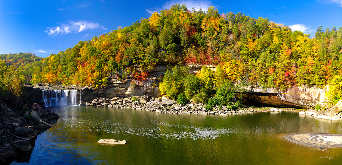
Cumberland Falls (Whitley and McCreary County)
GPS: N 36°50.3194', W 036°50.3194'
Roaring Cumberland Falls at 68 feet tall and 125 feet wide certainly lives up to its “Niagra of the South” moniker. 3,600 cubic feet of water spills over sandstone cliffs into the gorge below every second to create an awe-inspiring sight and sound. View these majestic falls from above or below in Cumberland Falls State Resort Park. Visit during a full moon for the chance to witness a rare moonbow, one of only two that occurs in the world.
7
Parking and Dog Slaughter Trail #414 Tailhead
GPS: N 36°51.5604', W 084°17.9922'
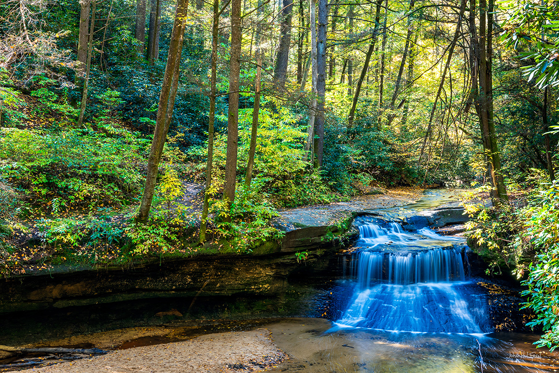
Dog Slaughter Falls (Corbin)
GPS: N 36°51.5112', W 084°18.7122'
Dense strands of hemlock and rhododendron and massive boulders line the 2.4-mile out-and-back moderately challenging trail to the stunning Dog Slaughter Falls. This is a very popular area for hiking and walking and you will likely encounter other people while exploring. The trail is open year-round and is beautiful to visit anytime. Dogs are welcome, but must be on a leash. Dog Slaughter Falls Trail runs parallel to Dog Slaughter Creek through beautiful and dense strands of hemlock and rhododendrons. Near the mouth of the creek, the 15-foot Dog Slaughter Falls provides a scenic place to enjoy nature and the surrounding area. The trail meanders over and around massive boulders and ends at the Cumberland River.
8
Parking and Sheltowee Trace Trail Access
GPS: N 36°59.8370', W 084°17.0843'
Vanhook Falls (London)
GPS: N 37°01.4634', W 084°16.8504'
Five miles out and back of incredible natural beauty and wonders can be found on the section of the Sheltowee Trace Trail that leads to the 37 foot Vanhook Falls. Along the way, several smaller unnamed waterfalls, high stone bluffs, and the large rock slabs and formations of Cane Creek make for an unbelievably scenic hike before reaching the waterfall, which plummets into a stunning sandstone cathedral. Located in the Daniel Boone National Forest, this is one of Kentucky’s most beautiful sites.
9
Double Falls Hiking Trail Trailhead
GPS: N 37°04.5174', W 084°17.3238'
Pine Island Double Falls (London)
GPS: N 37°04.2640', W 084°17.7976'
Hikers can locate the unmarked trailhead for Pine Island Double Falls Hiking Trail along the gravel Double Falls Trailhead Road, where there is parking space for one or two cars available at the trailhead with additional parking sites just beyond it. Within Daniel Boone National Forest lies a rare double waterfall, Pine Island Double Falls, where two powerful blue cascades meet in the middle and plunge into a pristine aquamarine pool below. You can access this impressive hidden gem via a 1.4 mile trek that follows a creek and features numerous natural wonders, such as caves, gorges, canyons and rock formations. As with most waterfalls, the best time to visit is right after a heavy rainfall.
10
Parking and Flat Lick Falls Trailhead
GPS: N 37°22.3254', W 083°56.3100'
Overlook GPS: N 37°22.2552', W 083°56.4392'
Flat Lick Falls (Jackson/McKee)
GPS: N 37°22.2509', W 083°56.4151'
At 33 feet tall, Flat Lick Falls makes an impressive plunge into a beautiful pool surrounded by boulders and cliffs. It’s an easy walk on the 1-mile loop trail to the waterfall, but if you are feeling more adventurous just cross the creek above the waterfall and follow the trail to the base. There are multiple trails for viewing the falls, including a paved one to an overlook. The falls’ deep blue pool is popular for wading or swimming.

11 Parking GPS: N 37°29.6015', W 084°13.5956'
Angline Falls Trail Trailhead
GPS: N 37°29.6054', W 084°13.5821'
Anglin Falls (Rockcastle)
GPS: N 37°29.8944', W 084°12.9697'
Streams trickling over rock cliffs, lush greenery and wildflowers line the way to jaw-dropping Anglin Falls, located in the wooded ravine of John B. Stephenson Memorial Forest State Park. The short 1.6-mile out-and-back hike up to Anglin Falls is mostly uphill and offers views of limestone outcroppings and small caves with a few challenging spots. It’s considered a moderate route, though, taking less than an hour to complete with benches for resting along the way. Dogs are not allowed on this trail.

12 Parking GPS: N 37°46.2055', W 083°34.0093'
Rock Bridge Trail #207 Trailhead
GPS: N 37°46.2120', W 083°33.9762'
Creation Falls (Wolfe County)
GPS: N 37°46.1634', W 083°33.7031'
Venture into the rugged Red River Gorge to Creation Falls with its family-friendly plunge pool that’s great for wading. The 1.4 mile out-and-back Rock Bridge Trail is considered moderately challenging and is one of the most visually stunning trails in the Gorge. Along the way to the arch (rock bridge) for which the trail is named, you’ll come upon magnificent Creation Falls. If you start the loop going clockwise, you’ll descend first into the woods to a scenic creek.
13 Parking GPS: N 37°49.2202', W 083°34.4977'
Trailhead GPS: N 37°49.2596', W 083°34.5365'
Copperas Falls (Wolfe County)
GPS: N 37°50.4860', W 083°34.2886
Though the trail to this gorgeous 40-foot waterfall is an unofficial one, meaning it isn’t marked or maintained, it is a popular, well-worn route for hikers and campers. The 3.1 mile out-and-back trail is moderately challenging but well worth the trek. Copperas Falls unexpectedly appears like a hidden oasis with a turquoise lagoon at its base and a massive rock shelter behind it that is a known archeological site once inhabited by prehistoric Native Americans.

14 Whittleton Campground GPS: N 37°46.8138', W 083°40.4598'
The trailhead is located at the north end of Whittleton Campground which is closed in the Winter. Park behind the chains on the sides and take the road all the way back to reach the start of the trail.
Whittleton Arch Trailhead
GPS: N 37°46.9582', W 083°40.3831'
From the Whittleton Arch trailhead, follow the Whittleton Arch Trail #100 a little more than a mile to reach the intersection with Whittleton Arch Trail #217
Whittleton Arch Trail #217 Trailhead
GPS: N 37°47.1534', W 083°39.6453'
From there, turn onto the Whittleton Arch Trail #217 and hike a quarter-mile uphill to reach the arch and falls.
Whittleton Arch Falls (Wolfe County)
GPS: N 37°46.9658', W 083°39.7115'
One of the most naturally beautiful trails in the Red River Gorge leads you to Whittleton Branch and Whittleton Arch Falls. The 5.25-mile out-and-back trail to the falls in considered easy and is well marked and simple to navigate. Once at the incredible arch and waterfall, walk behind the falls for a unique view. The best time to visit Whittleton Arch Falls is during Kentucky’s wettest season from winter through spring.
15
Lick Falls Overlook Trail Trailhead
GPS: N 38°12.2014', W 083°01.6768'
Lick Falls (Grayson Lake State Park)
GPS: N 38°11.8248', W 083°02.7702'
Nestled within the sheer sandstone cliffs, breathtaking hidden coves and caves of beautiful Grayson Lake lies scenic Lick Falls. Rated moderately strenuous, the 3-mile looped Lick Falls Overlook Trail follows the cliff line near the lake, offering unforgettable views of Grayson Lake below on the way to the peaceful falls. Paddlers can access Lick Falls via the lake (considered the best blueway east of the Mississippi), enjoying the amazing vistas and serenity year-round.
16
Parking at Little Mud Lick Church of God (do not park above the falls or along the road)
GPS: N 37°50.4462', W 082°50.9748'
Little Mud Lick Road
GPS: N 37°50.4704', W 082°50.9635'
Creek Access GPS: N 37°50.4456', W 082°51.1230'
Jenny Wiley Falls (Johnson County)
GPS: N 37°50.4162', W 082°51.2010'
A short 0.9 mile out-and-back moderately challenging hike takes you to the 30-foot Jenny Wiley Falls on Little Mud Lick, where courageous pioneer Jenny Wiley was once held captive by eleven Native Americans in 1789. Considered a moderately challenging route, the trail to this tranquil waterfall is known to birders, hikers and rock climbers but is quiet and secluded, making it a great spot to explore, relax and unwind. March through October are the best months for visiting. Dogs are not allowed on this trail.
17 Trailhead GPS: N 36°44.2775', W 083°44.4429'
Honeymoon Falls (Pine Mountain State Resort Park)
GPS: N 36°44.5187', W 083°44.5636'
This 1.0-mile loop trail is located behind Pine Mountain State Resort Lodge and is generally considered a moderately challenging route that is great for birding, camping, and hiking. You won’t likely encounter many other people while exploring. You will travel through a forested area to a small 25-foot waterfall, and there is beautiful foliage and streams in early spring and summer along the way. After the waterfall, you can continue walking the loop along steep and semi-rugged terrain. The best times to visit this trail are September through November.
18 Parking and Trailhead GPS: N 37°58.1334', W 085°57.6900'
Tioga Falls (Fort Knox Military Reservation)
GPS: N 37°57.7250', W 085°58.4860'
This 2.0-mile out-and-back trail on the Fort Knox Military Reservation is generally considered a moderately challenging route and is a very popular area for birding, hiking, and running, so you'll likely encounter other people. The trail is open year-round and is beautiful to visit anytime. Dogs are welcome but must be on a leash. The trail used to serve as a stagecoach route and as part of the old Louisville Nashville Turnpike and about 1/3 of a mile from the trailhead the trail splits to form a loop which passes by 2 large train trestles that are still operational, so be cautious and stay off of the tracks. You will soon pass by an old set of stone steps which lead downhill to the remnants of an old spring house near the creek below which was used as a stopping place for carriages in the 19th century. After about a mile you will come to the falls, which are actually a series of falls, or cascades if the water flow is light. At the top of the falls there used to be a resort in the 1800s where people would spend their summers to escape malaria. From top to bottom, the falls are about 130 feet high. At the falls the trail turns and loops back to the trailhead. The lower portion of the loop follows Tioga Creek for approximately half a mile. The trail soon reconnects, leading back to the parking area. The trail to the falls is open most of the year with the exception of black out dates during large military exercises at the base. Fort Knox is a very secure facility, so stay off of the falls and stay on the trail.
19 Fairmount Falls Trailhead GPS: N 38°05.5176', W 085°34.7370'
Fairmount Falls (Jefferson Memorial Forest, Jefferson County)
GPS: N 38°05.5814', W 085°34.6774'
Fairmount Falls Park, managed by Jefferson Memorial Forest, limits access to this park to three vehicles per day. To access this park, you need to contact the Jefferson Memorial Forest Welcome Center to obtain a free hiking permit a day in advance. This upland woodland 0.9-mile easy trail is filled with diverse plant life including ferns, wildflowers, mosses, shrubs, and native trees where you can experience an abundance of wildlife, including deer, turkey, upland birds, reptiles, amphibians, and other animals that live in streams. Woodland Falls is a 70-foot woodland waterfall that, with care, can be walked across at the top. When the water is flowing, great views can be seen from the trail that approaches from the parking area. Hikers who want a longer trek can hike a short in-and-out trail that extends past the waterfall.

20 Parking Riverfront Park GPS: N 38°00.3060', W 086°09.7740'
Buttermilk Falls Trailhead GPS: N 38°00.2424', W 086°09.8934'
Buttermilk and Emmert Falls (Brandenburg, Meade County)
GPS: N 38°00.0876', W 086°09.6486'
The Buttermilk Falls Trailhead offers a 2.5-mile (5 mile round trip) paved, accessible trail along Flippins Run Creek, connecting Riverfront Park to KY-933, featuring small waterfalls from hillside springs, picnic spots, and a connection to the Emmert Falls Primitive Trail. It's a family-friendly spot for walking, biking, and enjoying nature, with features like a footbridge and benches, and is known for spring wildflowers and fall foliage.
The trail surface is paved asphalt, making it suitable for strollers, wheelchairs (with appropriate tires), and bikes. The trail is rated easy to slightly moderate, with mostly gentle grades. The trail features Buttermilk Falls (small cascades), a wooden footbridge, picnic tables with benches, and a connection to the Emmert Falls Primitive Trail at the "Learning Tree.” Just after a half mile, Buttermilk Falls is on the right. This is not a large waterfall but a small cascade.
The 1.2 mile Emmett Falls Trail spurs off the main path and is considered a primitive trail, with more dirt and elevation than the Buttermilk Falls trail, ending with the more secluded Emmert Falls, where visitors can enjoy a quiet pavilion and a peaceful atmosphere. Near the creek branching off from the falls at Gerry Lynn Park, picnic tables are nestled among the trees for a shaded retreat. At the junction where these two trails meet, visitors will find a historic, 100-year-old Osage orange tree—a beloved local landmark surrounded by handcrafted sassafras benches.

 ADVERTISEMENT